

 Please log in to see the coordinates.
 3x Found
  0x Not found
  0 notes
  0 watchers
  Rated as: Excellent
 1 x recommended


 Cache attributes


 Description
EN
Description
EN
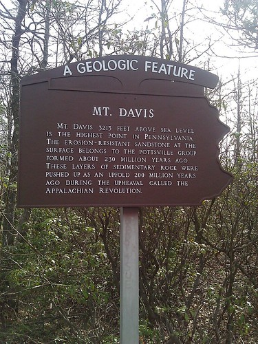
Mount Davis, Elevation 3213 Feet above Sea Level, is the highest point in The Commonwealth of Pennsylvania. It is a slight prominence on a 30 mile ridge named Negro Mountain, that runs SW to NE from Deep Creek Lake in Maryland to The Casselman River in Pennsylvania. This ridge is part of the Allegheny Plateau, although just a few miles west of the Ridge and Valley Region of the Appalachian Mountains. The high point was named after John Nelson Davis, an early settler and Cilvil War Veteran, surveyor, and naturalist, known for his study of Flora and Fauna on the Mountain. Mount Davis is on State Forest land, and can be reached by car or several hiking trails, the most popular being the High Point trail from the Mt. Davis Picnic Area, a .8 mile one way hike with a 300 foot elevation gain. At the very least, you must park about 400 feet away from the summit, and take a wide hiking trail with minimal elevation gain through the woods to access the high point.
How to get there: Mount Davis is about 10 miles SW of Sommerset, Pa., or 7 miles West of Salisbury, Pa. We highly recommend downloading this informative brochure (with directions from either town, and topographic map of the area) from the Pa. DCNR. Our party found that Mount Davis was a preloaded point of interest in our Magellan Roadmate automotive GPS.
What you will find there: Several trails intersect a circular gravel trail. Within the borders of the circular gravel trail you will find the true high point, a 60 foot observation tower built by the CCC in 1935, and several informative plaques placed on natural boulders. The coordinates at the top of the page should take you the to approximate center of these informative plaques. The true high point is not well maked, and not easy to find! But we will tell you how to find that later. This cache does not require you to climb the observation tower.
How to log this cache: Find the plaque titled SHRUBS & FLOWERS. How many of the listed Shrubs and Flowers begin with the word "Mountain"? We will call this number A. Now find the plaque titled INDUSTRY. Fill in the missing word: "The last to shut down and leave the mountain was the ______". We will call the number of letters in the missing word B.
A + B = The logging password for this cache. Spell the number out, in all lowercase letters.
How to find the true high point: As mentioned, it is not well marked or documented. Our party wasn't even sure we had found it, as there was no one around for miles to ask. But we did figure it out on site, and after we got home found documentation on the internet. Are you still standing in front of the INDUSTRY plaque? Looking directly at the Observation tower, and about halfway between the two, see the tallest boulder around, with a point reaching skyward? There is a weathered Benchmark on top of it, which looks like it's had many a vandalism attempt over the years. That is the highpoint of Pennsylvania. Yes, boulders count, apparently. Enjoy your visit! Note that by clicking on the nearest caches on Geocaching.com link on this cache page that there is an Earthcache with posted coordinates less than 50 feet from the posted coordinates of this cache, or a regular sized traditional cache less than 200 feet from these posted coordinates.
 Pictures
 Log entries:
3x
0x
0x
Log entries:
3x
0x
0x


